SYSTEMATIC GEOGRAPHY AND INTEGRATED COASTAL ZONE MANAGEMENT (ICZM) FOR THAILAND
By
Sombat Yumuang e - mail : sombat@gisthai.org
 Department of Geology, Faculty of Science, Chulalongkorn University, Bangkok 10330 Department of Geology, Faculty of Science, Chulalongkorn University, Bangkok 10330
Geo-Informatics Center for Thailand (www.gisthai.org)
Introduction
This review paper will provide some new key concepts and ideas of systematic geography that can be applied in integrated coastal zone management (ICZM) for Thailand. In addition, the important tools for studying the fields of systematic geography include: cartography, geographic information systems (GIS), remote sensing, mathematic modeling, and statistics are also briefly introduced. Finally, the first step in the implementation of ICZM for Thailand is also proposed in this paper.
Understanding the coastal zone environment with systematic geography
Geography is the study of the evolving character and organization of the Earth's surface. Regional geography is concerned with how the Earth's surface is differentiated into unique places, while systematic geography is concerned with the processes that differentiate places in time and space (figure 1).)
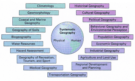 Figure 1.
 Fields of systematic geography (after Strahler, A. and Strahler, A., 2003)
Within systematic geography, human geography deals with social, economic, and behavioral processes that differentiate places, and physical geography examines the natural processes occurring at the Earth's surface that provides the physical setting for human activities. Climatology is the science that describes and explains the variability in space and time of the heat and moisture states of the Earth's surface, especially in land surface. Geomorphology is the science of Earth's surface processes and landforms. Coastal and marine geography combines the study of geomorphic processes that shape shores and coastlines with their application to coastal development and marine resource utilization. Geography of soils includes the study of the distribution of soil types and properties and processes of soil formation. Biogeography is the study of distributions of organisms at varying spatial and temporal scales, as well as the processes that produce these distribution patterns. Water resources and hazards assessment are applied fields that blend both physical and human geography.
Important tools for studying the fields of systematic geography include: cartography, geographic information systems (GIS), remote sensing, mathematic modeling, and statistics.
Cartography is the art and science of map-making. A map is a paper representation Of space showing point, line, or area data - that is locations, connections, and regions. It typically displays some characteristics or features of the Earth's surface that are positioned on the map in much the same way that they occur on the surface. The map's scale links the true distance between places with the distance on the map.
Maps, like the books, are very useful methods for storing information, but they have limitations. In the past two decades, striking advances in data collection, storage, analysis, and display have let to the development of geographic information systems (GIS). These spatial databases rely on computers for analysis, manipulation, and display of spatial data.
Another important geographic technique for acquiring spatial information is remote sensing, or which aircraft or spacecraft provide images of the Earth's surface. Depend on the resolution of remotely sensed data image, the information obtained can range from fine local detail to a global scale picture.
Tools in physical geography also include mathematic modeling, and statistics. Using math and computers to model geographic processes is a powerful approach to understanding both natural and human phenomena. Statistics provides methods that can be used to manipulate geographic data so that we can ask and answer questions about differences, trends, and patterns.
Spheres, scales, systems, and cycles are four overarching themes that appear in physical geography. The four great Earth realms are atmosphere, hydrosphere, lithosphere, and biosphere (figure 2). The processes of the great realms operate at multiple scales, including global, continental, regional, local, and individual.
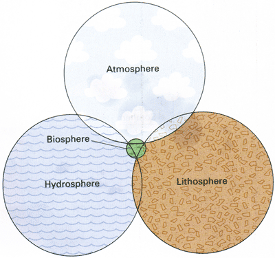 Figure 2.
 The Earth realms, shown as intersecting circles (after Strahler, A. and
Strahler, A., 2003)
Physical processes often act together in an organized way that we can view as a system. A system approach to physical geography looks for linkages and interactions between processes
Natural systems may undergo periodic, repeating changes that constitute time cycles. Important time cycles in physical geography range in length from hours to millions of years.
Physical geography is concerned with the natural world around us - the human environment. Natural and human processes are constantly changing that environment. Global climate is changing in respond to human impacts on the greenhouse effect. Global pathways of carbon flow can influence the greenhouse effect and are the subject of intense research interest. Maintaining global biodiversity is important both for maintaining the stability of ecosystems and guarding a potential resource of bioactive compounds for human benefit. Unchecked human activity can degrade environmental quality and create pollution. Extreme events take ever-higher tolls on life and properties as population expand. Extreme weather - storms and droughts, for example - may be more frequently with global warming caused by human activity.
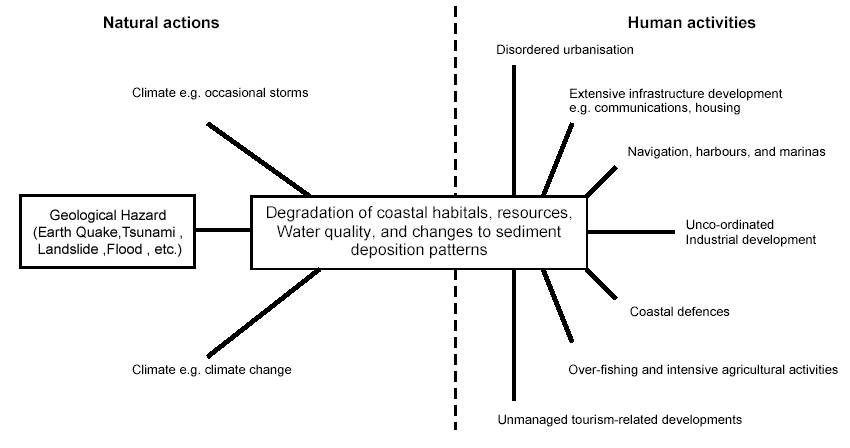
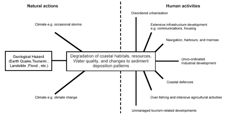 Figure 3.
 Natural actions and human activities that cause rapid degradation of coast habitats
and resources, and changes to processes ( after Naish, M., and Warn, S., 2001)
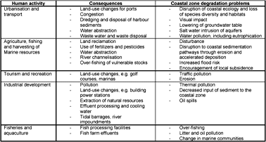 Figure 4.
 Relationship between human activities and coastal zone problems ( after Naish, M.,
and Warn, S., 2001)
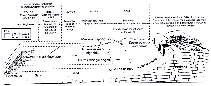
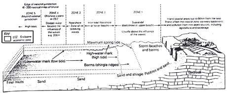 Figure 5.
 The five subdivision zones of coastal zone. The shoreline (zone 2-4) or coastal
waters can also include estuaries and lagoons. Zone 1 can also include coastal
wetlands, marches, sand dunes, cliff faces, and cliff tops ( after Naish, M., and
Warn, S., 2001)
What is integrated coastal zone management (ICZM) ?
Integrated coastal zone management (ICZM) is a dynamic, multidisciplinary and iterative process to promote sustainable management of coastal zones. It covers the full cycle of information collection, planning (in its broadest sense), decision making, management and monitoring of implementation. ICZM uses the informed participation and cooperation of all stakeholders to assess the societal goals in a given coastal area, and to take actions towards meeting these objectives. ICZM seeks, over the long-term, to balance environmental, economic, social, cultural and recreational objectives, all within the limits set by natural dynamics. 'Integrated' in ICZM refers to the integration of objectives and also to the integration of the many instruments needed to meet these objectives. It means integration of all relevant policy areas, sectors, and levels of administration. It means integration of the terrestrial and marine components of the target territory, in both time and space.
The first step in the implementation of ICZM for Thailand
From the increasing environmental and related problems in many parts of our coastal areas, the national research project should be urgently proposed to examine how the management of coastal activities such as conservation, development and tourism should be integrated more effectively to help ensure the long-term sustainable development and protection of Thailand's coastline. This new project will mark the first step in the implementation of integrated coastal zone management (ICZM) of our country to undertake an "overall stocktaking to analyze which major actors, laws, and institutions influence the management of our coastal zone" and then to develop national strategies to deliver ICZM.
The devolve administrations should join together to commission the stocktaking for the country. The project will make a detailed analysis of how different organizations interact with each other at the coast by:
- Describing the environmental, social and economic characteristics and natural resources of the country's coast;
- Identifying the different laws, agencies and other stockholders that influence the management and planning on the coasts;
- Analyzing how these bodies integrated with each other and identify any gaps, overlaps and opportunities.
The stocktaking will cover the whole of the country and should provide the information we need to maintain an effective framework that supports sustainable development in our coastal areas.
References:
Naish, M., and Warn, S 2001. Changing environments (fourth impression). Longman, Edinburgh Gate Harlow, Essex. Strahler, A. and Strahler, A., 2003. Introducing physical geography (third edition). John Wiley&Sons, Inc.
http://www.defra.gov.uk/environment/marine/iczm/pdf/wave_8.pdf
|