Three-Dimensional GIS Models of Land Subsidence in Bangkok Metropolis from 1990-1997
โดย ผู้ช่วยศาสตราจารย์ สมบัติ อยู่เมือง ผู้ช่วยศาสตราจารย์ สมบัติ อยู่เมือง
ศูนย์วิจัยภูมิสารสนเทศเพื่อประเทศไทย จุฬาลงกรณ์มหาวิทยาลัย [ GISTHAI ]
e - mail : ysombat@chula.ac.th
Abstract
It has been evident for years that several organizations
have constructed various types of benchmarks as to indicate subsiding
areas in Bangkok Metropolis. In 1992, there were about 1,200 benchmarks,
which was constructed by the Royal Thai Survey Division (RTSD), Department 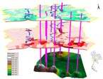 of Mineral Resources (DMR), Bangkok Metropolitan Administration (BMA)
and National Environmental Board (NEB), scattered throughout Bangkok Metropolis.
of Mineral Resources (DMR), Bangkok Metropolitan Administration (BMA)
and National Environmental Board (NEB), scattered throughout Bangkok Metropolis.
This study aims at compiling and presenting three-dimensional
models of land subsidence during 1990 to 1997 by applying the secondary
data from Department of Mineral Resources (DMR), Royal Thai Survey Department
(RTSD), Bangkok Metropolitan Administration (BMA) and National Environmental
Board (NEB). Synthesized by Geographic Information Systems softwares,
namely, Arc View GIS and Arc View 3D Analyst, the model will clearly demonstrate
significant land subsiding areas year by year. Through this means, land
subsidence in Bangkok Metropolis can be estimated and monitored interactively
corresponding to environmental management in the future, such as groundwater
or flood control and so on.
|